
Vacanze al Lago di Molveno, Dolomiti di Brenta
![]()
![]()
![]()
![]()
![]()
![]()
![]()
![]()
![]()
![]()
![]()
![]()
![]()
![]()

|
Crossing the Brenta Dolomites, Trentino: from Andalo to the Tovel lake The route begins at
the Maso Pegorar in Andalo (path no. 301. First it climbs the slopes of Monte
Dagnola, then after a short stretch it turns eastwards and runs along the great
ridge of this mountain until it reaches the Sega Grande peak and comes to the
Fontana Fredda area, near to which runs path no. 302 which climbs up from
Sporeggio. |
| starting point: | Andalo – Maso Pegorar mt 1041 |
| finishing point: | Lago di Tovel |
| maximum height: | 2376, Bocchetta di Val Scura |
| difference in height | about 1400 m. |
| time required | 7-8 hours |
| Principali Valli attraversate: | Valle dello Sporeggio, Val dei Cavai |
| refuges etc. along the way | baito Cacciatori Spora, Malga Campa, Malga Loverdina |
| path numbers | Path
310 to the Baito Cacciatori Spora lodge, 338 from here to the Malga Campa,
370 to the Malga Loverdina ** and at the fork path 330 coming from the
Malga Flavona as far as the Malga d’Arza.
** From the Malga Loverdina taking path no. 339 to the Malga Termoncello
and to Lake Tóvel. |
| Trentino bus connections | Trentino bus connections |
| recommended period | june - september |
| difficulty level | tiring, not difficult |
 |
 |
| Sella del Montoz vom Weg 338 | Panorama vom Passo Val Scura |
 |
 |
|
The climb
begins to the Val Scura Pass on path 369 |
s.338 and the Cima di Santa Maria |
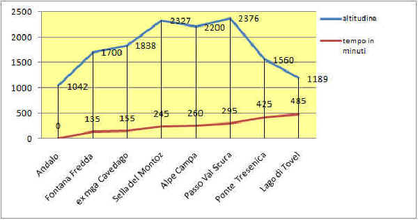
Table of times between points and heights: from Andalo to the Tovel Lake
| area | path nr. | height | time between areas | time from start | notes,
route variations
|
| Andalo- Maso Pegorar | 301 | 1042 | 0 | 0 | - |
| vic.ze Fontana Fredda confluenza 302-301 | 301 | 1700* | 2,15 | 2,15 | - |
| ex malga Cavedago,fork 338 | 338 | 1838 | 0'20 | 2,35 | along path 301 to Malga Spora |
| Sella del Montoz | 338 | 2327 | 1,30 | 4,05 | 
elaborazione su gentile concessione Ditta Cormar- Bolzano |
| Alpe Campa, fork 369-338 | 369 | 2200* | 0,15 | 4,20 | |
| Passo di Val Scura | 369 | 2376 | 0,35 | 5,05 | |
| Ponte Rio Tresenica | 314 | 1560 | 2,10 | 7,15 | |
| Lago di Tovel | 314 | 1189 | 1,00 | 8,15 |
Visualizza Parco Adamello Brenta, Settore Brenta in una mappa