Vacanze al Lago di Molveno, Dolomiti di Brenta

|
GENERAL INFORMATION |
|
| Altitude | m.2489 |
| Location | Conca di Pratofiorito |
| number of beds | 38 |
| telefono , fax | 0465-501309 |
| website - e-mail | |
| opening period indicative | 20.6 – 20.9 |
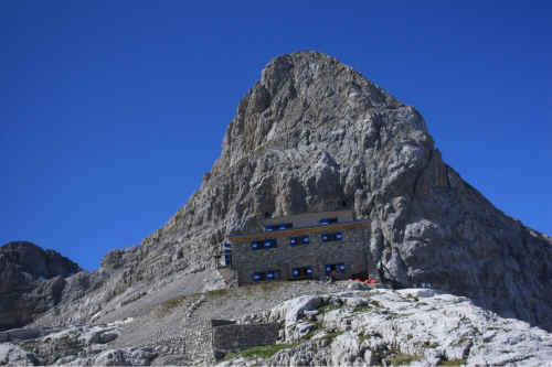
Il rifugio Dodici Apostoli
|
Access routes to the Refuge: From Giustino in the Rendena Valley along the northern ridge of the Flanginech Valley on path 307 |
||||
| difference in height : m. 1719 | maximum height: m.2489,R.12 Apostoli | |||
| Description | ||||
|
area |
height | time between areas | time from start | notes, route variations |
| Giustino, fraz.Badaione | 770 | 0 | 0 | - |
| Malga Bregn de l'ors,fork 307 bis | 1630 | 2,30 | 2,30 | Tartarotti path to Prà Rodont |
| Passo Bregn de l'Ors, fork 357 | 1836 | 0,45 | 3,15 | Path to Dos Sabion, Pinzolo cable car |
| fork 307-354 | 1900 | 0,05 | 3,20 | Path 354 to the Malga Movlina |
| fork 307-324,Val Nardis | 1830 | 0,15 | 3,35 | path 324 to Lago Valagola |
| Rifugio 12 Apostoli | 2489 | 1,45 | 5,20 | - |
|
Access routes to the Refuge: From Massimeno in the Rendena Valley on path 354 |
||||
| difference in height : m. 1628 | maximum height: 2489, R.12 Apostoli | |||
| Description: from Massimeno, the smallest municipality in Trentino, climb up the mule-track along the southern ridge of the Flanginech Valley as far as the Malga Plan and then towards the Dos dei Cavai peak to the Malga Movlina, the Gotro Pass and the Bregn de l’Ors Pass where the path meets the one climbing up from Giustino | ||||
|
area |
height | time between areas | time from start | notes, route variations |
| Massimeno | 861 | 0 | 0 | - |
| Malga Plan | 1588 | 2,00 | 2,00 | - |
| Malga Movlina, fork 341 e 350 | 1786 | 0,40 | 2,40 | path 341, access route to the refuge along the Sacco Valley, path 350 coming from Binio (Montagne) along the Manez Valley |
| Passo del Gotro,,bivio 333 | 1847 | 0,15 | 2,55 | path.333 to Malga Nambi in Val Algone |
| Passo Bregn de l'Ors, fork 357 | 1836 | 0, | 3,25 | path. to Dos Sabion, funivia Pinzolo |
| fork 307-354 | 1900 | 0,05 | 3,30 | path 354 per Malga Movlina |
| fork 307-324,Val Nardis | 1830 | 0,15 | 3,45 | path 324 per Lago Valagola |
| Rifugio 12 Apostoli | 2489 | 1,45 | 5,30 | - |
|
Access routes to the Refuge: From the Malga Movlina and Algone Valley along paths 354 and 307 |
||||
| difference in height : m.703 | maximum height:m.2489 Rif. 12 Apostoli | |||
| Description: accessible by climbing up the long Algone Valley by car as far as the Ghedina Refuge. From here access is permitted for a limited number of cars only (40 per day) subject to payment of a fee obtainable from the automatic ticket machine in the car park. | ||||
|
area |
height | time between areas | time from start | notes, route variations |
| Malga Movlina | 1786 | 0 | 0 | |
| Passo del Gotro, | 1847 | 0,15 | 0,15 | |
| Passo Bregn de l'Ors, fork 357 | 1836 | 0,30 | 0,45 | |
| fork 307-354 | 1900 | 0,05 | 0,50 | |
| fork 307-324,Val Nardis | 1830 | 0,15 | 1,05 | |
| Rifugio 12 Apostoli | 2489 | 1,45 | 2,50 | |
|
Access routes to the Refuge: From the Malga Nambi and Algone Valley along paths 341b e 341 |
||||
| difference in height : m.703 | maximum height:m.2620 Passo 12 Apostoli | |||
| Description: from the Ghedina Refuge to the Malga Nambi (1,375 m.): go up as far as the car park and then turn right and take path 341b (which runs into path 301 a little higher up) to climb up the Sacco Valley past the Dodici Apostoli Pass (2,620 m.) until you come to the Dodici Apostoli Refuge. | ||||
|
area |
height | time between areas | time from start | notes, route variations |
| Malga Nambi,parcheggio,fork 333 | 1375 | 0 | 0 | path 333 to Malga Movlina |
| Baito dei Cacciatori, fork 341 | 1800 | 1,00 | 1,00 | going left you come to the Gotro Pass |
| Passo dei 12 Apostoli | 2620 | 2,20 | 3,20 | |
| Rifugio 12 Apostoli | 2489 | 15 | 3,35 | see map |
|
The Ideale path near the Bocca d’Ambiez pass. |
Tackling the Ferrata Ettore Castiglioni route (with fixed rope supports) |
Visualizza Parco Adamello Brenta, Settore Brenta in una mappa di dimensioni maggiori
|
|


