
Vacanze al Lago di Molveno, Dolomiti di Brenta
![]()
![]()
![]()
![]()
![]()
![]()
![]()
![]()
![]()
![]()
![]()
![]()
![]()
![]()
|
Dolomiti di Brenta, Rifugio La Montanara |
|
GENERAL INFORMATION |
|
| Altitude | m.1525 |
| Location | Pian di Tovre |
| number of beds | 36 |
| telefono , fax | 0461 - 585603 |
| website - e-mail | - |
| opening period indicative | 1.6 - 30.9, 24.12 - 7.1 |

| Access routes to the La
Montanara Refuge: from
Molveno with the Molveno-Pradel Tovre chair-lift (open from Easter to
mid-October, at Christmas, New Year and weekends from January to mid-March) |
| Access routes: from Molveno along the path 352 | |||||
Difficulties |
maximum height : m.1525, Rif. Montanara |
||||
|
difference in height: 660 metri circa |
|||||
| Description: popular and scenic itinerary | |||||
| area | path | height | time between areas | time from start | notes, route variations |
| Molveno,via Belvedere, vicinanze croce | 352 | 930* | 0 | 0 | 
Cartina su gentile concessione Editrice La Giralpina |
| Val Biole, parcheggio | 352 | 1200* | 0,45 | 0,45 | |
| Albi del Mont | mulatt. | 1500* | 0,35 | 1,20 | turn left onto the mule-track |
| Rifugio Montanara | - | 1525 | 0,20 | 1,40 | - |
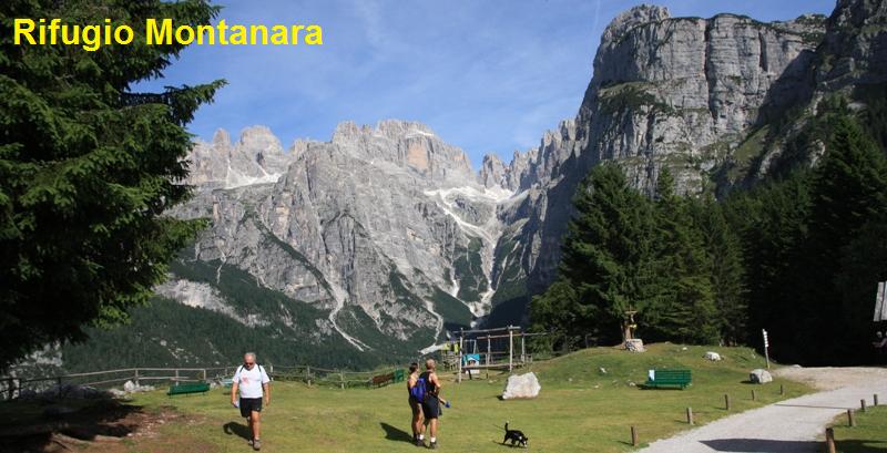
|
 The
Brenta Dolomites Group seen from the meadow in front of the Montanara Refuge |
| Access routes: from Molveno along the Deft path and the 340 and the Grotte path, 340b | |||||
Difficulties |
maximum height : m.1525, Rif. Montanara |
||||
|
difference in height: 660 metri circa |
|||||
| Description: popular and scenic itinerary | |||||
| area | path | height | time between areas | time from start | notes, route variations |
| Molveno,via Belvedere secondo tornante | sent Deft | 920 | 0 | 0 | near
the play area take the unmetalled road to the left |
| fork path. 340 | 340 sin | 1330* | 1,00 | 1,00 | turn left |
| fork 340 e 340b | 340b | 1330* | 0,10 | 1,10 | turn right |
| Rifugio Montanara | - | 1525 | 0,40 | 1,50 |
|
| Access routes to the La Montanara Refuge: from Andalo to the Val Biole car park and the Pradel road | |||||
Difficulties |
maximum height : m.1525, Rif. Montanara |
||||
|
difference in height: m.325 |
|||||
| Comment: route that first follows the unmetalled road from Andalo to Pradel and then climbs up the Carbonare ski run in the middle of the woods. | |||||
| area | path | height | time between areas | time from start | notes, route variations |
| Parcheggio di Val Biole, | strada | 1200* | 0 | 0 | carry on along the unmetalled road to Pradel |
| Aquai | strada | 1300* | 0,30 | 0,30 | keep going straight on |
| bivio per M.Tovre | pista sci | 1400* | 0,25 | 0,55 | keep going straight on up the ski run |
| Rifugio Montanara | - | 1525 | 0,20 | 1,15 |
|
|
The
initial stretch of the Grotte path |
Swings
near the Montanara Refuge |


Visualizza Parco Adamello Brenta, Settore Brenta in una mappa di dimensioni maggiori
|
|