Vacanze al Lago di Molveno, Dolomiti di Brenta

|
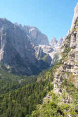
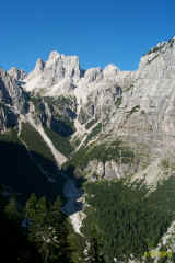
Brenta Dolomites - The access valleys and paths. Val Perse The Perse
Valley links the Croz Altissimo Refuge to the Bocca del Tuckett pass and is
crossed by path 322. This is a valley with little vegetation which nestles
between the Cima Vallazza and Roma peaks in the east and the Naso dei Massodi,
Spallone dei Massodi and Cima Brenta (once called the Cima di Val Perse) peaks
in the west. Near the Busa dell’Acqua hollow path 314 turns to the north to
cross the Bocca Vallazza pass and to then join path 301 in the direction of
Spora or Grostè. Path 314 on the other hand passes near the Malga Flavona. Just
before the Bocca del Tuckett pass path 322 intersects path 303, the Oswaldo Orsi
path, which leads to the Pedrotti Refuge via the foot of the Sfulmini chain of
peaks, offering wonderful views. |
 |
 |
|
Val Perse und Cima Brenta vom Croz Altissimo gesehen |
Torrente Massodi |
 |
 |
| Bocca Vallazza | Le Val Perse viste dal Sentiero Grotte |
| starting point | Molveno o Altipiano Pradel (Cabinovia da Molveno) |
| Connections with public transport | TRENTINO TRASPORTI |
| By motor vehicle | not permitted |
| Nearest refuges or bivouacs | Rifugio Croz Altissimo, Malga Spora, Rifugio Tuckett |
| Main itineraries | Molveno Rifugio Tuckett via Bocca di Tuckett |
| Difference in height | a) da Molveno metri 1783 b) da Pradel metri 1327 |
| Maximum height | Mt 2647, Bocca del Tuckett |
| other itineraries | a) sent 322 e 344 per Passo Clamer e Malga Spora |
| - | b) sent 322,344, 344b (passo del Lasteri), 352b per Rifugio Montanara |
| - | c) sent. 322, 314 per Bocca Vallazza e Malga Flavona o Passo Grostè e Madonna di Campiglio |
| - | d) Molveno Val perse Sentiero Orsi Rifugio Pedrotti |
| - | e) Molveno Bocca Tuckett Sent.ro Benini Passo Grosté |
| - | f) Molveno Val Perse, Bocca Tuckett,Bocchette Alte |
Table of times between points and heights: Molveno - Rifugio Tuckett
Visualizza Parco Adamello Brenta, Settore Brenta in una mappa di dimensioni maggiori


