
Vacanze al Lago di Molveno, Dolomiti di Brenta
![]()
![]()
![]()
![]()
![]()
![]()
![]()
![]()
![]()
![]()
![]()
![]()
![]()
![]()

|
Brenta Dolomites - The access valleys and paths. Val Doré. The
Doré and San Lorenzo valleys offer a route to the Pedrotti Refuge that was
followed by the “Sborzi”, the nickname of the family of workers who helped
to built the Tosa Refuge. The valley runs from the south to the north, starting
from the Prada meadows. Path 345 begins from the Alpenrose Refuge and climbs up
a mule-track as far as the La Rì meadows; it then cuts diagonally across the
Coste del Cor and goes in a north-easterly direction towards the Crona Saltere
peak. Here it turns to the left (northwards) and begins the climb up the Doré
Valley. To the west tower the rock faces of the Dos Arnal and Cima di Ghez peaks,
while the slopes of the Cima Soran and Rossati (or “reddened” from the
presence of red rock) peaks bound the valley to the east. After crossing the
Rossati Pass (2,442 m.), the path begins the descent along the San Lorenzo
Valley until, at about 1,980 metres, it goes around the eastern flank of the
Piccolo Dos di Dalum peak. |
 |
 |
|
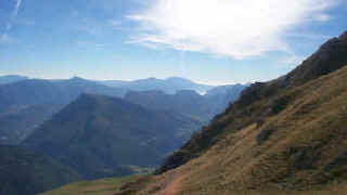
The
high meadows which lead to the Doré Valley, top right |
|
 |
 |
| starting point | Rifugio Alpenrose, m.1074 |
| Connections with public transport | TRENTINO TRASPORTI till San Lorenzo |
| By motor vehicle | till parking near the Alpenrose Refuge |
| Nearest refuges or bivouacs | Rifugio Al Cacciatore |
| Main itineraries | towards the Pedrotti Refuge across the Rossati Pass: paths 345 and 320 |
| Difference in height | m.1727 |
| Maximum height | m.2491, rifugio Pedrotti |
| difficulty | Tiring and demanding, little used |
| other itineraries | a) from the Al Cacciatore Refuge to the Forcella di Bregain Col (path 351, part of the Garda-Brenta route) b) Garda-Brenta route to the west passing the Costa de l’Ors mountain slope and the Mase Alte e Basse as far as the La Cros area on the Ambiez Valley road. |
 |
 |
| Dos Dalum, Cima Ghez and Forcolota di Noghera |
View
of the Giudicarie Valley from the Dos Arnal peak |
|
Table of times between points and heights: Rifugio Alpenrose - Rifugio Pedrotti along the paths 345 and 320. |
|||
| Route point |
alt. |
time from start in hours | possible route variations |
| Rifugio Alpenrose | 1074 | 0 | - |
| detour 345-345b | 1541 | 1,20 | Going westwards path 345b joins path 351 and from here a) to the north (turn right) towards the Malga Ben and Al Cacciatore Refuge b) to the south-west towards the former Malga Dorsino and then along path 349b towards the Mase Alte e Basse until you come to the Ambiez Valley road. |
| Passo dei Rossati | 2358 | 3,40 | |
| Spigolo est Dalum | 1980* | 4,40 |  Cartina su gentile concessione Editrice La Giralpina |
| Forcolotta di Noghera,detour 320 (right) | 2423 | 6,10 | |
| detour 320-326 (left) | 2414 | 6,25 | |
| Rifugio Pedrotti | 2491 | 7,50 | |
Visualizza Parco Adamello Brenta, Settore Brenta in una mappa