Vacanze al Lago di Molveno, Dolomiti di Brenta

|
RIFUGIO ALIMONTA, BRENTA DOLOMITES, TRENTINO: Excursions starting and finishing at the Almonta Refuge |
| Circular tours starting from the Alimonta Refuge: tour of the Bocchette Centrali with paths 319, 305 and 323 | |||||
|
Difficulty: Route with fixed ropes of middling difficulty |
maximum height : metri 2770, spigolo est della Torre di Brenta |
||||
|
difference in height: 650 metri circa |
|||||
Comment: One of the loveliest itineraries in the Dolomites |
|||||
| area | path | height | time between areas | time from start | notes, route variations |
| Rifugio Alimonta | 323 | 2580 | 0 | 0 | MAP |
| Rifugio Brentei | 318 | 2182 | 1,10 | 1,10 | - |
| Bocca di Brenta, fork 305 | 305 | 2552 | 1,00 | 2,10 | |
| Bocc. del Campanil Basso | 305 | 2620 | 1,00 | 3,10 | |
| Bocca dei Armi | 323 | 2749 | 2,00 | 5,10 | |
| Rifugio Alimonta | 323 | 2580 | 0,30 | 5,40 | - |
Spigolo Torre di Brenta sulla via ferrata Bocchette Centrali, sullo sfondo la Paganella
| Circular tours starting from the Alimonta Refuge: Tour of the Bocchette Alte and Sosat on paths 323, 305, 303, 305b and 323 | |||||
Difficulty: Very long, tiring and difficult, better if spread over 2 days |
maximum height : Passaggio su Spalla di Brenta, m.3020 |
||||
|
difference in height: 770 metri |
|||||
Comment: The most difficult route with fixed rope supports in the Brenta Dolomites |
|||||
| area | path | height | time between areas | time from start | notes, route variations |
| Rifugio Alimonta | 323 | 2580 | 0 | 0 | MAP |
| Bocca dei Armi a sinistra (nord) | 305,sin | 2749 | 0,40 | 0,40 | |
| Bocc.Bassa Massodi, fork 396 | 305 | 2790 | 1,00 | 1,40 | |
| Bocc. alta Massodi | 305 | 2950 | 0,50 | 2,30 | - |
| Cengia Garbari | 305 | 2950 | 0,40 | 3,10 | - |
| Cima Brenta, spalla nord | 305 | 2910 | 1,30 | 4,40 | - |
| Bocca di Tuckett | 303 | 2648 | 0,50 | 5,30 | - |
| Rifugio Tuckett | 305b | 2270 | 0,50 | 6,20 | - |
| Vallone dei Brentei, | 323 | 2380 | 2,00 | 8,20 | - |
| Rifugio Alimonta | - | 2580 | 0,40 | 9,00 | - |
 |
 |
|
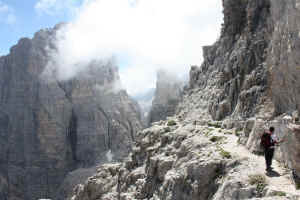
Campanil Bass e Brenta Alta tra le nebbie dal sentiero delle Bocchette Central |
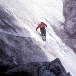
Canalino innevato sulla Cengia Garbari |
| Circular tours starting from the Alimonta Refuge: Tour of Cima Molveno, paths 323, 305, 396 and 323 | |||||
|
Difficulty: Short but relatively difficult stretch with fixed rope supports |
maximum height : metri 2790, Bpcchetta Bassa dei Massodi |
||||
|
difference in height: 210 metri |
|||||
Comment:Fixed rope supports along the difficult Oliva Detassis and Coggiola paths which run from the Bocchetta Bassa dei Massodi to the Bocchetta di Cima Molveno |
|||||
| area | path | height | time between areas | time from start | notes, route variations |
| Rifugio Alimonta | 323 | 2580 | 0 | 0 | MAP |
| Bocca dei Armi | 305,sin | 2749 | 0,40 | 0,40 | |
| Bocc.Bassa Massodi, fork 396 | 396 | 2790 | 1,00 | 1,40 | |
| Sperone ovest di cima Molveno, fork 323 | 323 | 2510 | 0,45 | 2,25 | - |
| Rifugio Alimonta | - | 2580 | 0,30 | 2,55 | - |
Visualizza Parco Adamello Brenta, Settore Brenta in una mappa

