
Vacanze al Lago di Molveno, Dolomiti di Brenta
![]()
![]()
![]()
![]()
![]()
![]()
![]()
![]()
![]()
![]()
![]()
![]()
![]()
![]()

|
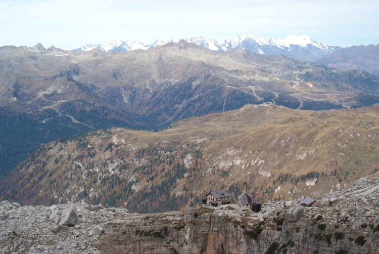
Dolomiti di Brenta, Rifugio Graffer This refuge lies in a strategic position in the Brenta Group. Along with the nearby Grostè Pass it is a junction for many of the routes that link the northern and central areas of the Brenta Group. It is also a passing point for itineraries running from east to north. |
|
|

|
| R. Graffer und Spinale | Catena Grostè and Graffer |
|
GENERAL INFORMATION |
|
| Altitude | 2261 |
| Location | Grostè |
| number of beds | 70 |
| telefono , fax | 0465- 441358 |
| website - e-mail | - |
| opening period indicative | 20.6 – 20.9 , 1.12 – 25.4 |
|
|
 |

|
Access routes: Da Madonna di Campiglio, Rifugio Vallesinella |
|||||
| difference in height: m. 737 | maximum height : m.2262, Rifugio Graffer | ||||
| Description: popular and scenic itinerary | |||||
| area | path | height | time between areas | time from start | notes, route variations |
| Rif.Vallesinella | 382 | 1525 | 0 | 0 |  Cartina su gentile concessione Editrice la Giralpina |
| Vallesinella di Sopra, fork 317,bis | 382 | 1681 | 0,50 | 0,50 | |
| vic.ze Fontana fredda, fork 331 | 331 | 2030 | 0,45 | 1,35 | |
| Rifugio Graffer | - | 2262 | 0,45 | 2,20 | |
|
Access routes: Da Madonna di Campiglio - Passo di Campo Carlo Magno |
|||||
| difference in height: m. 581 | maximum height : m.2262,Rifugio Graffer | ||||
| Description: a classic walk which leads to the “Orti della Regina” or Queen’s Gardens via the Pozza Vecchia hollow (to this point by car), the Pozza di Boch hollow and the Malga di Boch. | |||||
| area | path | height | time between areas | time from start | notes, route variations |
| Passo Campo Carlo Magno | - | 1681 | 0 | 0 | - |
| Rifugio Graffer | - | 2262 | 2,10 | 2,10 | - |

|
Access routes: from Passo del Grosté, cable car |
|||||
| difference in height: m. -- | maximum height :2442,Passo del Grosté | ||||
| Description: Access is
easier and more common when the cable car is running (June-September,
December-May). |
|||||
| area | path | height | time between areas | time from start | notes, route variations |
| Passo del Grosté | 301 | 2442 | 0 | 0 | - |
| Rifugio Graffer | - | 2262 | 0,25 | 0,25 | - |
|
Access routes: from Andalo along the path 301 to Malga Spora |
|||||
| difference in height: m. 1440 circa | maximum height: m2442,Passo del Grosté | ||||
| Description: together with the following one, this itinerary is one of the ways to cross the Brenta Group from the south-east to the west. Not very difficult and little used, it is recommended for those hikers who enjoy silence and the absence of fellow hikers. | |||||
| area | path | height | time between areas | time from start | notes, route variations |
| Andalo, maso Pegorar | 301 | 1042 | 0 | 0 | 
Elaborazione su cartina per gentile concessione ditta Cormar Bolzano |
| Malga Spora | 301 | 1851 | 3,00 | 3,00 | |
| Passo Gaiarda | 301 | 2242 | 1,10 | 4,10 | |
| fork 301-314 | 301 | 2206 | 0,40 | 4,50 | |
| Passo del Grosté | 301 | 2442 | 0,40 | 5,30 | |
| Rifugio Graffer | - | 2262 | 0,25 | 5,55 | |
|
Access routes: from Molveno along Val Perse and Bocca Vallazza, path 322, 314, 301 |
|||||
| difference in height: m. 1800 circa | maximum height : m.2453 , Bocca Vallazza. | ||||
| Description: a steep and rarely used route that comes up from the Perse Valley. Excellent views over the whole of the central chain of the Brenta Dolomites. | |||||
| area | path | height | time between areas | time from start |  Cartina su gentile concessione Editrice la Giralpina |
| Molveno,via Dolomiti | 319 | 880 | 0 | 0 | |
| Rifugio Croz Altissimo | 322 | 1430 | 1,30 | 1,30 | |
| Vallazza,fork 344 | 322 | 1600* | 0,30 | 2,00 | |
| Busa dell'Acqua, fork 322,314 | 314 | 1920 | 1,00 | 3,00 | |
| Bocca della Vallazza | 314 | 2453 | 1,45 | 4,45 | |
| fork 314-301 | 301 | 2206 | 0,35 | 5,20 | |
| Passo del Grosté, Rifugio Stoppani | 301 | 2442 | 0,40 | 6,00 | |
| Rifugio Graffer | - | 2262 | 0,25 | 6,25 | |
Visualizza Parco Adamello Brenta, Settore Brenta in una mappa di dimensioni maggiori
|
|