Vacanze al Lago di Molveno, Dolomiti di Brenta

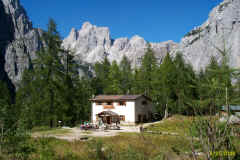
Dolomiti di Brenta, Rifugio Selvata
|
GENERAL INFORMATION |
|
| Altitude | m.1630 |
| Location | Pian della Selvata |
| number of beds | 24 |
| telefono , fax | 04611862900 |
| website - e-mail | www.rifugioselvata.it |
| open | 20.6 – 20.9 |
|
Access routes: from Molveno to the Seghe Valley via the Croz Altissimo Refuge |
||||
| difference in height: m. 750 | maximum height : m.1630, Rifugio Selvata | |||
| normal access route via “La Val”, as the Seghe Valley is called by the inhabitants of the area. | ||||
|
area |
height | time between areas | time from start | notes, route variations |
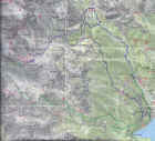
| Molveno,via Dolomiti | 880 | o | o |  Cartina su gentile concessione Editrice La Giralpina |
| Baita Ciclamino, bivio Sent.Donini | 926 | 10 | 0,10 | |
| Busa del Formai, bivio 319-322 | 1300* | 50 | 1,00 | |
| Rifugio Croz Altissimo, bivio 322,340 | 1430 | 30 | 1,30 | |
| Rifugio Selvata | 1630 | 40 | 2,10 | |
Access routes : from Molveno via Malga Andalo e Dos dei Casinati |
||||
| difference in height: m. 795 | maximum height :: m.1630, Rifugio Selvata | |||
| Description
: alternative route that links the Malga Andalo Refuge with
the Selvata Refuge along the ridge of the Dos dei Casinati peak. Route
laid out by Celestino Donini who for decades was the manager of the
Pedrotti and Malga Andalo refuges. |
||||
|
area |
height | time between areas | time from start | notes, route variations |
| Molveno -Camping Strada Ponte Romano | 835 | 0 | 0 |  Cartina su gentile concessione Editrice La Giralpina |
| fork 332- 326 | 925 | 0,15 | 0,15 | |
| Malga Andalo | 1357 | 1,15 | 1,30 | |
| Rifugio Selvata, fork 319,340 | 1630 | 1,15 | 2,45 | |
|
Access routes : from Altopiano di Pradel on path 340. |
||||
| difference in height: m. 310 | maximum height : m.1630, Rifugio Selvata | |||
| Description
: from the top station of the Molveno-Pradel cable car follow
itinerary 340, by far the most popular access route to the Brenta refuges
from the southern side. |
||||
|
area |
height | time between areas | time from start | notes, route variations |
| Altopiano di Pradel | 1320 | 0 | 0 |  Cartina su gentile concessione Editrice La Giralpina |
| seghe del Marillon, fork Montanara | 1330* | 0,25 | 0,25 | |
| Rifugio Croz Altissimo, fork 322 | 1430 | 0,35 | 1,00 | |
| Rifugio Selvata | 1630 | 0,40 | 1,40 | |
Access routes: from Molveno along the Val delle Seghe, il piano del Brocon, on path 319. |
||||
| difference in height: m. 750 | maximum height : m.1630, Rifugio Selvata | |||
| Description
: classic route which from Busa del Formai (Tabele) goes up
the right bank of the Seghe Valley as far as the refuge |
||||
|
area |
height | time between areas | time from start | notes, route variations |
| Molveno,via Dolomiti | 880 | 0 | 0 |  Cartina su gentile concessione Editrice La Giralpina |
| Baita Ciclamino, fork Sent.Donini | 926 | 10 | 0,10 | |
| Busa del Formai, fork 319-322 | 1300* | 50 | 1,00 | |
| Rifugio Selvata | 1630 | 60 | 2,00 | |
Visualizza Parco Adamello Brenta, Settore Brenta in una mappa di dimensioni maggiori
|
|


