
Vacanze al Lago di Molveno, Dolomiti di Brenta
![]()
![]()
![]()
![]()
![]()
![]()
![]()
![]()
![]()
![]()
![]()
![]()
![]()
![]()
|
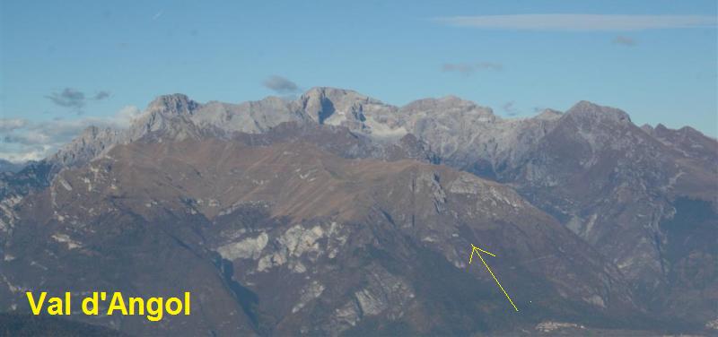
Brenta Dolomites - The access valleys and paths. Seo-Val d'Angol This
is a quite tiring itinerary in terms of the difference in height and the time
required (1,344 m., about 7 hours). It goes through totally unspoilt scenery
where traces left by humans date back centuries. From Seo (outlying district of
Stenico in the Giudicarie Valley, 832 m.) you come to the Al Cacciatore Refuge.
Take path 348 along the Angol Valley which goes across the Salti peak to the
slopes of Monte Brugnol and Monte Pizzo via the Malga Valandro (1,871 m., ruins)
and with to the east the rock spurs of the Valandro and Ghirlo mountains which
bound the parallel Inferno Valley to the west. |
|
 |
 |
| Seo and Sclemo | |
| starting point | Seo-Stenico , m. 832 |
| Connections with public transport | TRENTINO TRASPORTI |
| Nearest refuges or bivouacs | Rifugio Cacciatori San Lorenzo |
| Main itineraries | sent 348, itinerario Garda Brenta |
| Difference in height | 1344 metri |
| Maximum height | m.2276, selletta di Colmalta |
 |
 |
|
Malga Asbelz |
Marugini, la sella di Colmalta und Busa Senaso |
Table of times between points and heights: path 348 Seo - Rifugio Al Cacciatore
Seo Val d'Angol Malga Asbelz Rifugio al Cacciatore |
||||
| Difference in height: m. 1450 | Maximum height: m.2276,sella di Colmalta | |||
| Description: long
and tiring itinerary through unspoilt scenery. Better and less tiring if
used to go downhill rather than up. |
||||
| Route point |
alt. |
time between points in minutes | time from start in hours | possible route variations |
| Seo | 832 | 0 | 0 |  Cartina su gentile concessione Editrice la Giralpina |
| fork 348-346 | 1700* | 2,30 | 2,30 | |
| ex Malga Valandro | 1871 | 0,40 | 3,10 | |
| Sell.ta del Monte Piz | 2148 | 0,50 | 4,00 | |
| vic.ze Malga Sgolbia | 2004 | 0,10 | 4,10 | |
| Lago Asbelz, fork 348-349 | 2016 | 0,45 | 4,55 | |
| Sella di Colmalta | 2276 | 0,45 | 5,40 | |
| Rifugio al Cacciatore | 1821 | 2,30 | 8,10 | |
| Table of times between points and heights: path 346-348 Stenico - Rifugio Al Cacciatore along Val Laone - Malga Valandro- Malga Asbelz | |||||
| Route point | path |
alt. |
time between points in minutes | time from start in hours | possible route variations |
| Stenico | 346 | 666 | - | - | - |
| fork 347-346, Bus delle Contesse | 346 | 841 | 0,30 | 0,30 |
in
a westerly direction for the Malga Prato di Castello |
| Capitel della Spina 346-347 | 346 | 1450* | 1,45 | 2,15 | - |
| fork 348-346 | 348 | 1700* | 0,45 | 3,00 | - |
| ex Malga Valandro | 348 | 1871 | 0,45 | 3,45 | - |
| Sell.ta del Monte Piz | 348 | 2148 | 0,45 | 4,30 | - |
| Lago Asbelz, fork 348-349 | 348 | 1956 | 1,00 | 5,30 | possibility of returning to Baesa via the Jon Valley |
| Sella di Colmalta | 348 | 2176 | 0,50 | 6,20 | - |
| Rifugio al Cacciatore | - | 1821 | 2,30 | 8,50 | about another 2 hours are needed for the hike down to San Lorenzo in Banale |
Visualizza Parco Adamello Brenta, Settore Brenta in una mappa di dimensioni maggiori